|
|
News updates
30/05/2024: Thames Area Water Situation Reports, issued by the Environment Agency Groundwater Resources and Hydrology team.
May 2024:
Rainfall for the Thames area in May was 125% of the long-term average.
Areal units in the north-east received above normal rainfall and those in the south-east received normal rainfall.
Soil moisture deficits increased from April to 20mm across the area and were wetter than usual for May.
River flows across the area were almost all notably high or exceptionally high, with three sites having their second wettest May on record.
Groundwater levels at most of the indicator sites were above normal or higher but continued their seasonal decline.
June 2024:
Thames area received 18mm of rainfall in June, 34% of the long-term average. All our areal rainfall units were notably low, except for the Cotswolds West and Cotswolds East units, which were below normal for the time of year.
Soil moisture deficits increased from last month to 76mm across the area and was higher than expected for the time of year (61mm).
Monthly mean river flows at all our indicator sites decreased in June with all sites recording a normal or higher flows for the time of year.
At the end of the month, groundwater levels at nearly all our indicator sites continued their seasonal decline, with most of the groundwater indicator sites recording higher than normal levels for the time of year.
August 2024:
In August rainfall in the Thames area was 71% of the long-term average.
Most of the areaÕs areal units received normal rainfall, though the five north-eastern areal units received below normal rainfall.
Soil moisture deficits increased from last month and were slightly drier than the long-term average, with soils generally drier in the south compared to the north.
River flows at our indicator sites continued their usual seasonal decline and had monthly mean flows that were normal or above.
Groundwater levels at most of our indicator sites also continued their seasonal decline and ended the month with levels that were normal or above.
September 2024:
Thames area receiver 193mm of rainfall in September, 317% of the long-term average, making it the wettest month since records began in 1871.
Soil moisture deficits were reduced to zero and this resulted in high effective rainfall of 50mm (long-term average is 5mm).
Monthly mean flows increased at all our sites and 4 measured their highest ever September flows since site records began.
The seasonal declining trend of groundwater levels reversed at most of our sites in September, which is earlier than normal.
|
27/04/2020: Letcombe Brook otters
Just sharing a quick bit of good news - there are 3 otters using the brook at the moment - looks like a mother and 2 cubs! A resident got a very brief clip on his security camera, he lives Wantage side of Grove but doesnt want exact location disclosed. They could well be the young of the mature dog otter that was killed last October on the road at Grove. First time we have heard of cubs on the Letcombe Brook and great news indeed. They are fairly large already so wondering where she kept them up to now.
Photographs:
[View photo 1]
[View photo 2]
Link to video on Twitter: [View video]
|
12/02/2017: Grant
We have been successfull in applying for a grant from the Vale of White Horse district Council. We applied for £1,155 which will pay for our insurance, new waders, equipment and pay for any contractor to tackle any trees that are beyond our abilities.
|
06/12/2016: Survey - University of the West of England, Bristol
Dear Flood Group Members,
My name is Carly Rose and I am a postgraduate researcher at the University of the West of England, Bristol. My main interest is how people deal with the risk of flooding, and I am looking into some aspects that have not been investigated in much detail before here in the UK.
You are invited to take part in an online survey, which should take no more than 20 minutes of your time.
The first page you will see explains more about this research - having read that section, you will then be invited to click a box if you consent to participating and this will open the question section. If you should need to break off part way through, the same link will bring you back to where you left off.
My full contact details, and those of my academic supervisor, are also provided within the survey.
To begin, please access https://qtrial2013.qualtrics.com/SE/?SID=SV_b10kyt3xnyobN6l
[View participant information PDF]
With grateful thanks,
Carly B Rose PhD Researcher
Centre for Floods, Communities and Resilience
University of the West of England, Bristol
Email: carly2.rose@live.uwe.ac.uk
|
22/08/2016: Riverfly Monitoring Partnership
This project aims to establish a biological monitoring programme, run by local people, to continually assess the health of the Letcombe Brook. Group members will be trained to use the Anglers Riverfly Monitoring Initiative (ARMI), a technique used across the UK for monitoring the biological health of rivers. This involves taking 3-minute kick samples from the bed of the river, and identifying and recording 8 pollution sensitive invertebrate groups that are found in these samples.
The data from this will be held by the group. The data will also be shared with the Environment Agency who will be able to take action, including further scientific investigation, should invertebrate levels drop below expected levels.
Sites will be chosen that meet certain health and safety criteria for a safe sampling site. Each volunteer will sample one of these sites on a monthly basis to ensure that there is a continuous assessment of the water quality in the river. Serious pollution incidents can occur in our watercourses, and regular monitoring is the best available resource for identifying this early and allowing for a rapid response. The dataset held by the group will also allow for long term changes to be identified, and the monitoring activity will discourage potential polluters.
As well as protecting the local environment and ensuring the health of a crucial recreational resource, a key outcome of the project is to equip the communities who are most strongly affected by the health of the river with an understanding of its ecological status and the resources to protect it.
There is a need to have a scientific and quantitative way of measuring the "health" of our rivers. Invertebrates are the most useful available indicators of this. They are generally at the bottom end of the food chain, meaning that most fish, birds and mammals rely on a healthy population of invertebrates for their survival. Many invertebrates are also particularly sensitive to pollution, and these are the ones that will be used in this monitoring programme. This is the best way to identify pollution events as and when they occur, rather than waiting for more drastic effects such as fish death.
No prior knowledge is required and you have been chosen as you have an active interest in the Letcombe Brook. Please note this invitation is for you personally. We require a commitment from you that you are prepared to undertake the training (1 day) and that you are prepared to conduct surveys every month for at least a year. The sampling of a site should not take longer than 30 mins - 1 hour. If you are away for a say a month then we can cover that with the other volunteers on that occasion.
This is an important project as there is little or no monitoring of the health of the river going on by the Environment Agency or Thames Water and we need to be better equipped to deal with both developers and polluters.
Further information is also available at www.riverflies.org.
I would like you to invite you to take part in the Riverfly Monitoring training. The training will take place locally on one day (9-5pm) and the trainer is Ben Fitch from the Riverfly Partnership.
The options for the training are either Wednesday 12th October or Thursday 13th October.
If you would like to take part please could you let me know which dates you are available.
Please contact me via email at letcombebrook@hotmail.com.
Best wishes,
Sally Wallington
Letcombe Brook Project
C/o Vale and Downland Museum
Church Street
Wantage
OXON
OX12 8BL
|
20/01/2015: EA remove large tree downstream of Lower Mill
A very large tree fell across the brook downstream of Lower Mill around Christmas time. This was enormous and way beyond what we could tackle. The maintenance team of the Environment Agency were contacted and they have now removed this. They agreed it was a very difficult job even with their specialist equipment.
Photographs:
[Photo1] [Photo2]] [Photo3] [Photo4]
|
10/11/2012: Grove Airfield development update
Additional Information has been submitted regarding the planning application for the Grove Airfield development.
Alan Miles and Stewart Scott are studying this, but it would be great if you could also give your views directly to the Vale. Of particular interest to you may be the Hydrology section which covers flooding and the Transport section which includes proposals for new road layouts in our area.
The application number is P12/V0299/O and the information is on the Vale of White Horse District Council web site.
|
09/11/2012: Visit to the new Environment Agency Incident room
An EA incident room at Wallingford has recently opened and an open evening was held for interested groups. Members of both the Grove Green Flood Group and the Hanneys Flood Group attended and we used the opportunity to talk to as many EA staff as possible. Here are some bits of information that you may find useful:
EA Reorganisation
The EA has been reorganised and we are now in South East Region. The region is divided into 4 areas:
- West Thames
- North East Thames
- South London and South Downs
- Kent and South London
We are in West Thames area which covers an area from Banbury to Guildford.
We do now have a nominated person to contact and they are a team Leader covering Oxfordshire and Buckinghamshire.
Flood Warning registration
Within the Thames West region there are 117,196 properties within flood Risk 2 and 3, of which 80,178 have signed up to the EA flood warning service. The EA are keen to get as many people signed up as possible.
If you work or live within flood Zone 2 or 3 you can sign up via the online system but this system will not allow you to sign up if you are outside flood Zone 2 & 3. But anyone can sign up to the flood warning service by phoning the flood line on 0845 988 11 88.
Flood warning process
The EA monitor the river levels. If the water level rises above a specific level then the EA are alerted. They then look at the weather forecast, water level trends and other factors and may issue a flood Alert. The catchment area for us is River Ock from Watchfield to Abingdon and also Letcombe brook at Wantage, Grove and East Hanney this covers 4 separate local areas as follows:
- River Ock at Abingdon
- Letcombe Brook at Letcombe Bassett and Letcombe Regis
- River Ock at Longcot, Stanford in the Vale, Charney Bassett, Lyford and Garford
- Letcombe Brook at Wantage, Grove and East Hanney
If the flood alert is triggered in any ONE of the local areas a flood Alert is sent out to ALL local areas covered by the catchment area. This is important. As an example: If the water levels at Stanford in the Vale rise above the trigger level then residents in Letcombe Bassett will also get a flood alert!
The flood alert message will say which local areas are likely to be affected.
If however the water level continues to rise and a Flood Warning is issued then this should only go to those registered in the local area affected.
Wantage Water level gauge
The EA online water level gauge records data every 15mins, but the information is only downloaded once or twice per day. If water levels become very high then the data is downloaded more often. We asked if this could be changed so that it downloads every 15mins all the time just like the Grove Green Flood Group system but apparently to do this for all the water level gauges in England and Wales the EA estimate it would cost £1.6 million per year.
|
14/06/2012: Oxfordshire flood risk strategy
Oxfordshire County Council are conducting a survey to help draft their local flood risk management survey. It only takes a few minutes, if you can complete this it will help them. The following text in italics as from Oxfordshire County Council.
The county council is undertaking a consultation to inform the drafting of the Oxfordshire Local Flood Risk Management Strategy. The first part of this consultation is a questionnaire in order to gather specific information concerning flooding from residents, business and local groups in Oxfordshire.
Background:
Following the significant floods in 2007, the Government gave local authorities new powers to help manage local flood risk in a more coordinated way. The Flood and Water Management Act 2010 requires county councils to lead the coordination of flood risk management for surface water, groundwater and ordinary watercourses in their area.
Main river flooding remains the responsibility of the Environment Agency, but we understand that people don't distinguish between types of flooding when it happens, and that is why all the relevant agencies are collaborating on one local strategy.
The local flood risk management strategy will give a clear vision for how flood risk will be dealt with in Oxfordshire. The strategy will include the following:
- Information on local flood risk in Oxfordshire, highlighting where problems have already occurred and current levels of flood risk
- Clarification of which organisation is responsible for what in relation to the prevention and management of flooding
- Information on the measures that will be undertaken to reduce flood risk
- Clarification of how work is prioritised
- Measures that communities can undertake to improve flood resilience, as it is not possible to stop all flooding
Consultation:
We need to reflect the views and concerns of residents, businesses and local groups in the drafting of the strategy. The survey (see the link below) has been designed to help gather views
We encourage you to participate in the survey by following the link www.oxfordshire.gov.uk/floodriskstrategy.
The deadline for responses is 5th July 2012.
|
13/06/2012: Botney Bridge
Chris Surnam and Stewart did a height level survey of the road between Botney Bridge and West Hanney. The road dips to about 62.4 above sea level. In April 2012 we had local water levels at 62.8m and January 2010 at 62.7m. This gave rise to water levels on the road of 400mm and 300mm. We have a quote to increase the road height by 200mm over about 60m length of road. A rough estimate is £55,000. This is a very significant amount, so we shall think carefully about the problems at Botney Bridge and possible solutions.
|
13/06/2012: Tools grant from BTCV
We recently applied for a grant for tools from the British Trust for Conservation Volunteers (BTCV). This was successful and we now some more bow saws, a Hereford brushing hook, an Irish brushing hook, a rabbiting spade and a Newcastle draining spade. Come along to our next working party and find out what the difference is between an Irish and a Hereford brushing hook is; sounds like a good pub quiz question.
|
12/06/2012: Property level flood protection
Peter Dela from the vale of White Horse district council has been able to get a grant for some properties in East Hanney to have flood protection systems fitted. Only 2 property owners decided to take up the offer one of which includes the village hall. These have now been fitted. A big thanks to Peter for getting this grant.
|
11/06/2012: Grove Airfield update
We have been keeping a close eye on the proposed Grove Airfield development as the surface water drainage discharges into the Childrey Brook upstream of West Hanney and the increased treated sewage water discharges into the Letcombe brook upstream of East Hanney.
Included in the masses of documents submitted as part of the planning application was a Flood Risk Assessment. We have looked at this and submitted a series of questions on the 25th March. A response has just been received. Interestingly the developers are going to submit a Flood Risk Assessment Addendum in July 2012. We look forward to seeing this extra or revised information. If anyone wants to see the latest response please let us know and we will send it to you.
|
01/04/2012: Grove Airfield
The application to build 2,500 houses on the Grove Airfield has been submitted. There is a flood risk assessment and we have studied this and submitted some questions to the Vale of White Horse district council. The application can be found at
http://www.whitehorsedc.gov.uk/java/support/Main.jsp?MODULE=ApplicationDetails&REF=P12/V0299/O&TYPE=Application"
The Flood risk Assessment is under Volume II and is the last section marked Appendix 2.12A FRA. It is however 40Mb to download!
We do however have a CD of all the documents and a hard copy of the Flood Risk Assessment. If anyone wants to take a copy please let us know.
Comments can be sent to the Vale of White Horse District Council at the following email: planning@whitehorsedc.gov.uk.
There is another exhibition in Grove where we believe there will be some people we can ask questions to. The dates are 20th and 21st of April at the Old Mill Hall in Grove.
|
31/03/2012: Wantage Sewage Treatment Works
Anyone walking towards Grove will have noticed the new pipeline being put in connecting the Wantage Sewage Treatment Works to the Letcombe brook.
We visited the works in June 2008 and Thames Water had identified that although the filtration works has a capacity for a larger population the inlet works are at maximum capacity. The plan was that a new inlet pumping station, storm separation, 6mm screening plant and some improvements to storm separation and control would be implemented after April 2011. [VIEW OUR REPORT]
Thames Water have recently told us, via Iain Brown, our County Councillor, that the new outfall pipe is a supplementary storm outfall line, which is going in alongside the existing storm outfall pipe (and discharging to the watercourse at the same location as the existing storm discharge). The reason for this additional pipe is that the existing one doesn't have adequate capacity to deal with the anticipated peak storm flows that will occur once the new storm sewage PS that is being put in to relieve catchment surcharging/flooding is up and running
We are thinking about what these implications are and what other mitigation measures we can make.
|
15/02/2012: National Flood Forum conference
We are members of The National Flood Forum and their annual conference is in London on 7th March. The event is focussing on the issue of Insurance. Is there anyone who would like to go?. Details are available at
http://www.coastms.co.uk/conferences/456
|
22/10/2011: Sand bags
The Vale of White Horse District Council have updated their flood policy and decided that they can no longer supply sand bags. "The council can no longer guarantee the supply of sand bags to any premises, so residents and property owners are strongly advised to make their own arrangements to protect their property, particularly if they live in within a flood plain or if they know their property is susceptible to flooding. They should take steps themselves to help prepare and protect against the risk of flooding and the pages on the left give prevention tips as well as advice on what to do if you are affected by a flood".
[Link to Vale of White Horse District Council flooding advice]
The best solution is some engineered defence but there are other alternatives to sand bags such as aqua sacs which self inflate, are light and easy to store. There are many products on the market and you can see these at the National Flood Forums web site which includes Blue Pages which list all the flood defence products available.
[Sand bags and how to use them properly for flood protection]
|
04/09/2011: Grant for property level flood protection
We are very pleased to hear that Peter Dela of the Vale of White Horse District Council has obtained a grant for property level flood protection. The grant is only for properties that have greater than 1 in 20 years risk of flooding and flood water has entered the building at least once since 2000. Peter has arranged a surveyer to assess the eligible properties which are located near Dandridges Mill, the War Memorial Hall and shop and properties very close to Lower Mill. We understand that the Village shop and the War Memorial Hall are confirmed as eligible.
|
03/09/2011: Thigh high waders
We have been donated some thigh high waders from the Environment Agency; a big thanks to them. These are of a smaller shoe size which is good news for those of a smaller build who have been keen to get in the water but struggled with the size 9, 10 and 11 waders we had.
|
30/05/2011: Flood property insurance
We have received reports that getting insurance has suddenly become more difficult. We spoke to The National Flood Forum and they have also seen this problem. Their advice is as follows:
Obtaining quotes by the internet can be a problem, once one company refuses, the information seems to propagate to the other insurance companies and they respond in like manner. It is best to speak directly by phone to the insurance company or broker. Good quotes seem to be being obtained by Wilbys 01422 358 525 and by Sainsbury Insurance 0800 169 8755. Tesco are also offering insurance but only if a previous flood related claim was less than £60,000.
|
29/05/2011: Oxfam flood awareness campaign
Oxfam are running a campaign to raise awareness of flooding and would like people to write about what object they would save first in the event of a flood. This campaign is being coordinated by the National Flood Forum and will organise a photographer to take your picture and the object. If you want to take part please contact the NFF on 01743 741725.
|
08/05/2011: Water Vole and wild flowers
There has been a number of sightings of water voles around lower Mill over the past few months and now we have a picture of one, thanks to Clive. This is great news. According to Paul Sayers, water voles were quite common about 20 years ago but have not been seen for over 5 years in Hanney. Water voles are a protected species and have been in decline in recent years so these sightings are very good news. It does mean we have to be careful as it is an offence to deliberately, capture, injure or kill them or to damage, destroy or obstruct their breeding or resting places. So any work around Lower Mill will have to take this into account.
[View photo]
Last year we planted over 100 native wild flower seedlings along the brook edge between the iron bridge and the first style. Last month the Marsh Marigold were in flower and it looks like the other seedlings have established themselves. These included Greater Burnett, Hemp Agrimony, Meadow sweet, Valerian, Purple loosestrife and Fleabane. The flowers are designed to knit the bank together to reduce errosion as well producing an attractive display. The parish council have a grant to erects some display boards and hope to include photographs of flowers, mammals, insects and birds that could be seen by the brook. If you are a keen photographer keep and eye out and perhaps we could include some of your pictures on the boards.
|
02/05/2011: Willow Walk proposal
The possible proposal for a flood alleviation scheme at Willow Walk in Wantage is progressing. A detailed survey has been conducted and the EA are now conducting some modelling. The survey has identified 2 areas next to willow walk which are not owned by the District Council. These areas contain 2 separate balancing ponds that are designed to collect storm water from local housing developments and then allow the rain water to slowly feed into the letcombe brook, and so reduce peak flows and reduce the probability of flooding. However both these areas are heavily overgrown and in badly need of maintenance.
The District Council are looking at who owns them and we are looking at getting these refurbished.
This raises some questions. Are there any other similar housing development drainage systems in existence, who is maintaining them and are they regularly inspected? This is a very pertinent question as we expect more development in Wantage and Grove.
|
15/04/2011: Wildlife information panels
East Hanney Parish Council have been granted an award by the Big Lottery Fund for some pond dipping stations and information panels to be placed along by the Brook. If you would like to help in this please let us know. Last year we planted some wild flowers along the brook down-stream of the iron bridge so we hope to include some photos of these.
|
10/04/2011: Update on Exercise Water Mark
Alan Miles and Stewart Scott attended the community event in Oxford in March. This was an opportunity to discuss our draft flood plan, meet other groups and watch some demonstrations of flood equipment. It was apparent that we could expand the flood plan to be more general to cover other situations which we can help with. Patrick and Catriona Karney have taken on this task in developing a community emergency plan. The problem of vehicles causing property by bow waves was discussed a lot at the event. The ability to close roads due to flooding was discussed and the legal position was still not clear. The organisers have agreed to clarify the situation and will respond soon.
|
02/03/2011: Exercise Water Mark - 12th March
A number of us will be attending the Exercise Watermark community event on the 12th of March. This is a day long event in Oxford to carry out a desk top practice of our community flood plan. We have written a first draft of this and will see how it works out on the day. We will then update the plan as a second draft and send it out to everyone for comment. We hope then to carry out a practice later in the year.
The day will also include a presentation from Richard Benyon MP for Newbury and Minister for the Natural Environment and Fisheries, Question and Answer sessions, Displays and stands by various groups including The Flood Forum, Oxfordshire Rural Community Councils, Thames Valley Resilience Forum, Local Authorities from across the Thames Valley, The Environment Agency and St John Ambulance and live displays at the Environment Agency Depot including Sandbag displays, Demountable Flood Defences, Oxfordshire Fire and Rescue Service using High Volume Pumps and a water rescue display.
We will let you know how we get on
|
01/03/2011: Letcombe brook flows
We have been investigating methods of reducing the short duration but large flow rates on the Letcombe brook which occur after heavy rainfall. Last year we met with the Environment Agency, Letcombe brook project officer and District land drainage engineer to look for possible schemes. One that was identified was a possible scheme at Willow Walk in Wantage. The first stage was for the EA to investigate its suitability but this has been held up because of lack of funds. Some funds have now been found within the EA and the first stage of investigation work which comprises of a survey at 5m intervals is planned to be carried out in March by the EA.
|
21/02/2011: Storm water drains
There has been much activity by the Highways department looking at storm water drains. Apparently this is not a complete clean but preperation work prior to an inspection by remote cameras. Chris Surman in West Hanney is keeping a keen eye on this and will try and get hold of a report once the inspection is complete.
|
01/01/2011: Exercise Water Mark
In 2011 there is a week of national flood exercises. In addition to these national events, community groups are encouraged to develop their own local flood plan and test them at an event on the 12th of March in Oxford.
We would like to participate in this and so would like to develop an emergency plan. We shall probably need a couple of meetings in January and February to develop the plan.
If you would like to get involved please contact Stewart Scott on 01235-868503 or via the contact form and we shall arrange a date to suit as many people as possible.
|
13/12/2010: YouTube video
The Environment Agency have posted their video of the work being carried out by the Hanneys Flood Group on YouTube.
[Link to Environment Agency video on YouTube]
|
25/06/2010: Lowering of Lower Mill fixed weir
Robert Hodgson (The owner of Lower Mill) and the flood group obtained consent from the Environment Agency to remove 100mm from the fixed section of the weir at Lower Mill. This is now almost complete. We have removed one layer of brick and concrete which is probably about 70-80mm, there is a little bit more to do in one corner, and this should be completed soon. This may not sound a lot but it does make a difference in allowing greater flows for the same water height. Our policy is that lots of small things add up to a big difference.
|
04/05/2010: Trailer to store & transport equipment
We have been given some money by the Environment Agency to buy a trailer to store and transport our equipment. We have now obtained a trailer and this is kept locally. We do need someone to tow the trailer. Is there anyone who would volunteer to move the trailer a couple of times a year? The trailer has lights but will need a number plate.
|
15/01/2010: The Hanneys Flood Group win award
The Environment Agency held a Community Flood Heroes event on Friday 15 January 2010. The Hanneys Flood Group won "best example of community action to reduce flood risk" at the event organsied by the Thames West Region of the Environment Agency.
The event was designed to recognise the effort made by many communities to help reduce the probability of flooding in the future.
David Cameroon, MP for Witney, presented the awards.
Stewart Scott, Alan Miles and Paul Dyer represented the group and Iain Brown our County Counciller and Ed Vaizey our MP were at the event and heard about the work being carried out by other groups including Bourton-on-the-Water, Fairford, Witney & Buckelbury.
The award recongnises the effort made by many people over the past few years. So to everyone who has contributed, a big thanks. [View certificate]
[Link to Environment Agency article]
[Link to Wantage Herald article]
[Link to Oxford Mail article]
|
01/06/2009: Constitution
At our first AGM on May 13th, the Association's constitution was agreed and the management committee voted in. This formal process will enable the Group to fund further projects through grants and fund raising which is vital achieve the ongoing need to keep the floods at bay. The success of the voluntary work so far is clear to see and will continue throughout the year.
[View constitution Page 1] [View constitution Page 2]
|
30/05/2009: Grass cuttings and Himalayan balsam
We have been working with the Environment Agency over the past year to reduce the probability of flooding in East and West Hanney. During our work along the Letcombe Brook we have noticed two problems that we need your help with: grass cuttings and Himalayan balsam.
Grass cuttings that are left near the stream or on the river bank rots away and as part of this process a strong liquid 'effluent' or 'liquor' is produced. This liquor contains large numbers of the bacteria responsible for the decaying process and when grass cuttings are left to rot on the river bank the liquor will seep into the river. This is particularly evident when rainfall accelerates the leaching of the liquor into the river. The bacterial activity in the liquor will remove oxygen from the water and under certain conditions will kill fish and aquatic insects. The rotting grass cuttings also prevent growth of natural wild flowers and encourages the growth of stinging nettles or leaves bare patches on the river bank, leaving it susceptible to erosion. If you have grass next to the brook please remove the mowings from the waters edge and compost away from the stream.
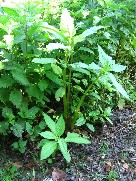
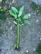
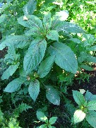
Himalayan balsam is a native of the western Himalayas . It was introduced to Britain in 1839, it escaped from gardens and rapidly colonised river banks and areas of damp ground. It is the tallest annual plant in Britain , growing up to 3m high. When the seed pods mature, they explode when touched, scattering seeds up to 7m away. Seeds are also spread by water and they remain viable for up to two years. Himalayan balsam plants grow in dense stands that suppress the growth of native plants. In autumn the plants die back, leaving the banks bare of vegetation, and therefore liable to erosion. We would like to prevent the Himalayan Balsam from setting seed and spreading further along the river. The plants are very shallow rooted and easy to pull up, so if you see any whilst out walking please help by pulling them up and leave them in a pile to rot down away from the waters edge.
Photographs of Himalayan Balsam are displayed on the right hand side of this page.
If you can help with this then it will improve the environment and reduce the amount of bank erosion and silting up of the brook
|
14/05/2009: New flood warning station for the Letcombe Brook
The Environment Agency is currently installing a new river water level gauge on Letcombe Brook. This gauge will be used by the Environment Agency to give flood warnings and it will be installed by the end of May 2009. However the EA can only update their Floodline Warnings Direct (FWD) system at certain times of the year and the next opportunity to do this will be October 2009. This means there will be four months where the EA have the information to give a flood warning but not the means of contacting people in at risk properties. The Hanneys Flood Group are working with the EA on a possible cascade system to cover these few months. Once we have more details we shall let you know.
The EA operate a number of monitoring stations. These consist of an instrument that measures and records the water level in a river, brook or even large ditch. Some of these stations need to be visited every few months by EA staff and the stored data down loaded for analysis. Other stations are connected by a telemetry system so that the EA can monitor the water levels remotely. The stations with telemetry are used as part of the system to determine when to issue flood warnings. At the moment the stations fitted with telemetry are on the Ock at Stanford in the Vale, Charney Basset and Abingdon and on the Letcombe Brook at letcombe Regis. To improve the accuracy of the flood warnings for Wantage, Grove and East Hanney a new river water level gauge is going to be fitted in Wantage. It may mean that the current warning system that covers "River Ock from Watchfield to Abingdon including, Stanford in the Vale, Charney Bassett, Lyford and Garford, and also the Letcombe Brook at Wantage, Grove, East Hanney, Letcombe Regis and Letcombe Bassett" will be split into seperate areas. The addition of this extra station should allow the flood warning system to be more accurate for Wantage, Grove and East Hanney.
|
19/01/2009: EA work on Letcombe Brook start date confirmed
We have been informed by the Environment Agency that the work on the Letcombe Brook down stream of East Hanney will commence on the 6th July 2009. This is excellent news.
|
|
|
|
|